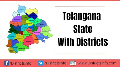
Telangana became the 29th state of India on June 2, 2014. It is 1,12,077 square kilometers big and has 3,50,03,674 people (2011 Census). Telangana was once part of Hyderabad state from September 17, 1948, until November 1, 1956. On November 1, 1956, it joined Andhra State to become Andhra Pradesh.
Telangana was created when both houses of Parliament passed the AP State Reorganization Bill. People had been asking for a separate state for a long time. It shares borders with Maharashtra and Chhattisgarh to the north, Karnataka to the west, and Andhra Pradesh to the south and east. Important cities in Telangana include Hyderabad, Warangal, Nizamabad, Nalgonda, Khammam, and Karimnagar.

Telangana State
Telangana has 33 districts, covering an area of 1,12,077 sq. km (44,273 sq. mi). The largest district is Bhadradri Kothagudem, and the smallest is Hyderabad. The districts include Adilabad, Hyderabad, Jagtial, Acharya Jayashankar, Kamareddy, Karimnagar, Khammam, Komarambheem, Kothagudem, Mahabubabad, Mahbubnagar, Malkajgiri, Medak, Nagarkurnool, Nalgonda, Nirmal, Nizamabad, Peddapalle, Rangareddy, Sangareddy, Shamshabad, Siddipet, Suryapet, Wanaparthy, Warangal, Yadadri, Jangaon, Sircilla, Gadwal, and Asifabad.
Telangana is a well-developed state with many industries, especially in and around Hyderabad. You can find cement industries in districts like Tandur and Miryalaguda. The Patancheru area in the Medak district is also industrially developed. There's a paper industry in Sirpur and a thermal power center in Kothagudem. The 7th longest national highway, NH no. 44, passes through different districts of Telangana.
Telangana has a history that dates back to the ancient Stone Age, with evidence found in various places like Vemulapalli, Eturi Nagaram, Basara, Bodh, Haaliya, Kathur, Veltur, Pochampadu, etc. The region has a rich history, mentioned in books related to Buddhism, and many archaeological excavations have revealed its past. Telangana was part of Hyderabad state until 1948, becoming a part of India on September 17, 1948. In 1956, Telangana and Andhra were combined to form the first linguistic state, Andhra Pradesh. The separate Telangana movement gained momentum in 1969.
In 2011, K Chandrasekhara Rao formed the Telangana Rashtra Samithi party for a separate Telangana state. Student and employee unions actively joined the movement. On July 30, 2013, the Congress Working Committee resolved for a separate Telangana state, approved on October 3, 2014. The Parliament approved the separate Telangana state bill, and it was officially formed on June 2, 2014, as the 29th state of India. Hyderabad remains the capital of Telangana, and it will be the capital of the residual Andhra Pradesh for ten years.
Facts on Telangana
| Official Website | www.telangana.gov.in |
| Country | India |
| State | Telangana |
| Date of Formation | 2 June, 2014 |
| Largest city | Hyderabad |
| Coordinates | 18° N 79° E |
| Chief Minister | Anumula Revanth Reddy |
| Governor | Tamilisai Soundararajan |
| High Court | High Court of Judicature at Hyderabad |
| Area | 1,12,077 km2 |
| Density | 307/km2 |
| Population (2011 Census) | 35193978 |
| Males Population (2011) | 17611633 |
| Females Population (2011) | 17392041 |
| No. of District | 31 |
| Capital | Hyderabad |
| Revenue Villages | 10434 |
| Revenue Mandals | 459 |
| Mandal Praja Parishads | 438 |
| Municipalities | 37 |
| Towns (as per 2011 Census) | 158 |
| Rivers | Godavari |
| Forests & National Park | Shivaram Wildlife Sanctuary, Manjira Wildlife Sanctuary |
| Languages | Telugu, Urdu |
| Neighbour States | Andhra Pradesh, Odisha, Chhattisgarh, Maharashtra, Karnataka |
| Literacy Rate (2011) | 66.46% |
| Females per 1000 males | 1010 |
| Assembly constituency | 119 |
| Parliamentary constituency | 17 |
List of Districts in Telangana State
Below is the table we have listed all the districts of Telangana State:
Telangana State
| State Overview | |
| State/UT : | Telangana (తెలంగాణ) |
| Capital : | Hyderabad |
| Established : | 2-June-2014 |
| Total Area : | 1,14,840 km² |
| Total Population (2011) : | 3,51,93,978 |
| High Court : | High Court of Telangana |
| State Symbols | |
| The State Bird : | Palapitta (Indian Roller or Blue Jay) |
| The State Animal | Jinka (Deer) |
| The State Tree | Jammi Chettu (Prosopis Cineraria) |
| The State Flower | Tangedu (Tanner’s Cassia). |
